


EULA — Richland Creek is an important water source for Searcy County.
The creek wanders through the hills and valleys of the Richland Wilderness Valley and eventually finds its way into the Buffalo National River.
Along the way to the Buffalo, the creek creates and is the end source for many waterfalls that can transport visitors into a simpler time.
A waterfall trip down Richland Creek Road can take visitors a week to see the 16 falls that are located along a five-mile stretch of the road.
There is also a waterfall trip that can be enjoyed by all. Handicapped individuals, or older residents never have to leave the car to see the natural beauty of the waterfalls. Three or the four waterfalls can be viewed from the road and the fourth waterfall can be viewed by taking just 20 steps.
The two major waterfalls on the trip are Falling Water Falls and Six Finger Falls. These falls are along the Falling Water Road.
After leaving Witts Springs, Falling Water Road is 12 miles from the junction of Arkansas highways 16 and 377. The road will be on the right hand side of the highway.
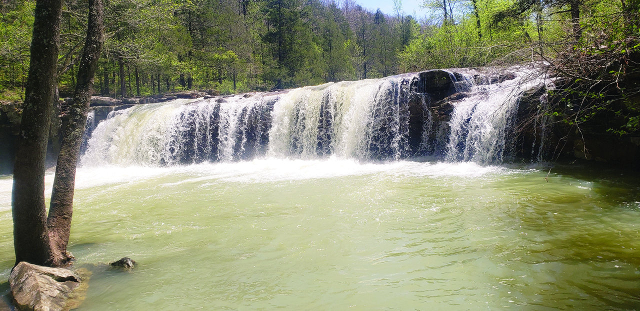
Falling Water will be the first falls down the road. It is located on the right side.
The history of Falling Water is unique. It served as a source of water for the community as late as the 1950s. The height of the falls varies by season.
During the spring when the creek is high from the heavy rains, the fall may be only 10 feet in height. During the summer months when the pool is used for community swimming, the height of the falls can reach 18 feet. The falls is very wide with several areas where water makes waterfalls.
Swimming is very common during the summer months for locals and visitors as well. Those who love the sun can take advantage of flat rocks at the top of the falls.
This is a great place to have a picnic with the family or bathe in the sun.
In spring some spirited individuals have been known to kayak over the falls.
Getting to the pool at the bottom of the falls has been greatly improved. The addition of steps from the road allows swimmers to reach the pool much easier.
On the east side of the pool, there is a tree that has several pieces of wood nailed to it. This used as a ladder to take swimmers from the pool to the top of the waterfalls. Visitors jump off the top of the rocks to awaiting waters below.
Continuing down Falling Water Road and only .1 of a mile from Falling Water Falls is an unnamed waterfall that comes from a contributory creek. This waterfall comes in a series of three drops and is 12 feet in height.
There are several places along this waterfall to stop and take selfies or family photos with the waterfall in the background.
Three miles from the second waterfall is Richland Creek Road as it joins Falling Water Road.
Just .1 of a mile from the intersection will be the third waterfall in the series.
This waterfall does require leaving the automobile to see. It is about 20 steps from the road; however, it is hard walking.
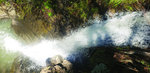
Intersection Falls, appropriately named, is recorded at 24 feet high. The view for visitors is from the top of the falls. It is a .5 mile hike to the waterfall’s bottom that may require a little wading in water to reach the falls.
From the road, there is a small branch that leads to Intersection Falls. It can be slippery.
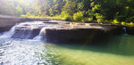
After getting back into the car, it is only .25 of a mile to Six Fingers Fall.
While the height of Six Fingers is recorded at six feet, the waterfall stretches near 100 feet in width.
When the spring waters have declined, there are six distinct waterfall fingers.
When finished finding waterfalls, the Richland Creek Campground is located down the road from Six Fingers Falls. It has picnic tables as well as vaulted facilities. This campground is operated by the Big Piney Ranger District.
Forty steps and four waterfalls is a great trip for young and old alike.


